


l'aupillon

Massiac15
User
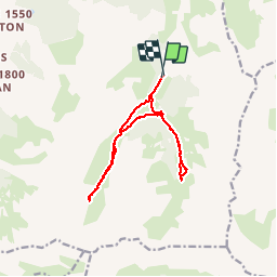

Length
13.4 km

Max alt
2352 m

Uphill gradient
668 m
Km-Effort
22 km

Min alt
1877 m

Downhill gradient
680 m
Boucle
Yes
Creation date :
2018-04-16 20:06:55.124
Updated on :
2018-04-16 20:06:55.124
6h27
Difficulty : Easy

FREE GPS app for hiking
 SityTrail
IGN / Geographical institutes
SityTrail Plus
The world is yours!
About
Trail Walking of 13.4 km to be discovered at Provence-Alpes-Côte d'Azur, Hautes-Alpes, Les Orres. This trail is proposed by Massiac15.
Positioning
Country:
France
Region :
Provence-Alpes-Côte d'Azur
Department/Province :
Hautes-Alpes
Municipality :
Les Orres
Location:
Unknown
Start:(Dec)
Start:(UTM)
310096 ; 4928532 (32T) N.
Comments